Follow this train of thought: cars have sensors, cars are infrequent use over large areas, cars are the ultimate distributed sensor network for weather conditions.
Many years ago, as I wasted yet another chunk of my life sitting in the linear parking lot that was my morning commute, I mused that there had to be a way to prevent this madness. I thought: What if there was a way for the cars to tell each other where slowdowns are? This was long before smartphones, so it would have to be done the hard way. I imagined that each vehicle could have a small GPS receiver and a wireless transceiver of some sort, to send the vehicle’s current position to a central server, which would then send the aggregate speed data for each road back to the subscriber’s car. A small display would show you the hotspots and allow you to choose an alternate route. Genius! I had finally found my billion dollar idea.
Sadly, it was not to be. Seemingly days later, everyone on the planet had a GPS-equipped smartphone in his or her pocket, and the complex system I imagined was now easily implemented as software. Comically, one of the reasons I chose not to pursue my idea is that I didn’t think anyone would willingly let a company have access to their location information. Little did I know.
So it was with great interest that I read an article claiming that windshield wiper data from connected cars can be used to prevent floods. I honestly thought it was a joke at first, like something from a Monty Python sketch. But as I read through the article, I thought about that long-ago idea I had had, which amounted to a distributed sensor platform, might actually be useful for more than just detecting traffic jams.
When the Rains Come
Right off the bat, we’ll stipulate that the headline of the article linked above is a bit of a stretch compared to the meat of the actual research. The article implies that OBDC data is being captured and mined in real time to develop a high-resolution picture of environmental conditions around a fleet of vehicles. While that’s clearly where the authors of the research paper from the University of Michigan see their results leading, it’s far from where they are right now.
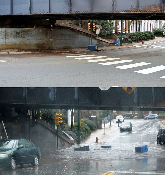
The research was aimed at addressing a very specific problem that civil engineers and urban planners face: it’s really hard to predict where and when flash floods will occur. To do so, you need to know exactly where and how hard it’s raining, down to a very fine granularity. Fixed weather stations with rain gauges are few and far between relative to the size of most urban areas and do not provide enough spatial resolution to give a good picture of the intensity of rainfall in small areas, like those experiencing microbursts. Weather radar is good for providing wide area coverage that fills in the gaps between rain gauges to some extent, but it suffers from resolution problems as well. The idea here was to correlate historical windshield wiper use in a fleet of instrumented vehicles with weather radar archives and fixed rain gauge readings of past storms, to see if data on wiper use can augment traditional rainfall measurements.
Filling in the Gaps
Perhaps unsurprisingly, they found that drivers tend to turn their wipers on when it rains, and the harder it rains, the faster the wipers are set. But the more important finding was that by subjecting the windshield wiper data and weather radar data to a Bayesian filtering network, the weather radar could be updated to locate areas where it was actually raining but that the radar missed, and to find “holes” in the rainfall pattern where the radar insisted it was raining.
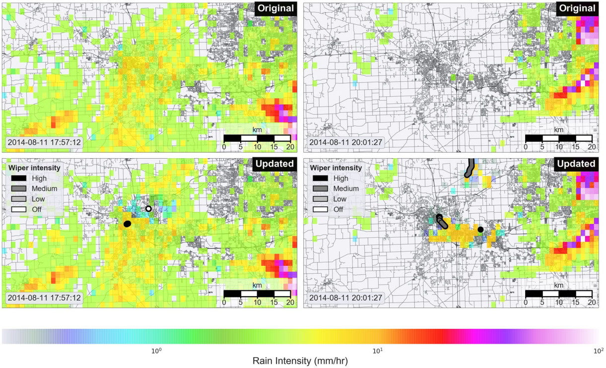
These updates were by no means small, spot showers; the updated areas that the radar misinterpreted were on the order of 10 km across. Given the size of some local watersheds, especially in urban areas, the assessment of “raining” and “not raining” over such an area could make the difference in accurately predicting a flash flood.
Despite the somewhat ambitious article, this study only lays the basis for a future in which connected vehicles can be used as remote mobile sensing platforms. One can imagine not only getting high-resolution rainfall data but also localized reports of temperature from exterior thermometers and assessment of road conditions from anti-lock brake and traction control system data.
There are huge hurdles between where we are now and the day that an urban planner can get high-resolution spatial and temporal data from vast numbers of connected vehicles plying their streets. But where there’s a wealth of data to be mined, you can bet your bottom dollar that someone has a plan to exploit it. The degree to which that benefits those that generate the data remains to be seen, but for now, it’s pretty cool to know that windshield wipers can, sort of, be used to predict flash floods.